Providing mobile access to GIS utility plan
Case study

Simplified utility surveying in the canton of Zurich thanks to GG04 plus with the mobile GIS utility plan
The Electricity Plant of the Canton of Zurich (EKZ), one of the largest Swiss energy supply companies, developed an innovative app that simplifies measurements and allows each field technician to visualise the collected information on the tablet directly on site. Thanks to the simple operation of the solution, employees save time and also have better control over their surveys – all while still on the construction site.
For more than ten years, EKZ employees have been using Leica Geosystems instruments to document their assets (power lines). Until a year ago, surveying was mainly carried out with the GPS System 1200 (ATX antennas and RX controllers).
The original working method
The GPS solution in use until the end of 2019, althoughvery effective,could only be used by specially trained employees. Moreover, the employee did not have an overview of the field surveys carried out on site, but could only examine them in the context of the existing utility plan back in the office, after importing them into the desktop GIS.
Location documentation
EKZ field technicians record the exact location of their assets (e.g. the power lines in the underground) during the inspection of the civil engineering work. The final documentation of these assets in the GIS is carried out in the office by internal draftsmen.
New working method
Since EKZ started surveying using GNSS, both the surveying solution and the geoinformation system have evolved considerably. Furthermore, work tools have changed as well: EKZ equipped its field technicians with tablets, providing them with mobile access to the GIS utility plan.

With the integration of the Leica GG04 plus antenna into the GIS utility plan (nisXplorer by NIS AG), EKZ has created a straightforward system for its field technicians. They can now carry out their work in the familiar environment of a mobile utility plan.
The end of the life cycle of the GPS System 1200 and its replacement with GG04 plus Smart Antennas was the starting point for the development of a new mobile solution called 'nisXplorer Mobile Survey' by NIS AG. The new system, consisting of a GG04 plus antenna and the Leica Zeno Connect app from Leica Geosystems, an iPad and the nisXplorer Mobile app, led to a significant simplification of the previous work processes at EKZ: Accurate coordinates are now available directly on the tablet, both for the documentation process in the utility plan as well as for staking out underground objects.
Coupling GG04 plus with utility plan from EKZ
Precise coordinates from the GG04 plus surveying antenna are directly linked via Zeno Connect app to the nisXplorer Mobile app. Field technicians see the measured objects on site in the GIS utility plan, which allows ongoing visual checks. While still on site, the data is conveniently sent by e-mail to the back office for further processing. Staking out also becomes much easier; the user can be guided directly to any objects picked up from the utility plan.
Simple and cost-effective
The integration of the new GG04 plus antenna, the Zeno Connect app, the EKZ tablets and the enhanced mobile nisXplorer Mobile app into one coherent system have significantly simplified the work for the EKZ employees. Thanks to the user-friendly operation of the whole system, surveying has become much easier and can now be carried out by every field technician. Reviewing the collected data is simple and can be performed in the familiar working environment of the utility plan directly on site. Due to the significantly reduced workload, EKZ was able to increase efficiency as well as save costs.

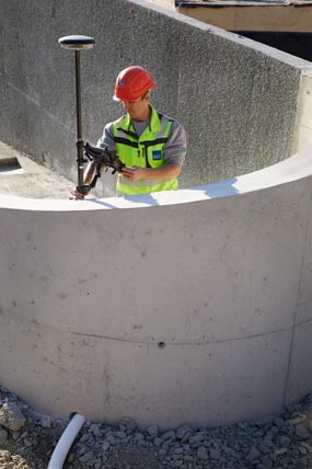
Surveying of EKZ assets is carried out by field technicians
About EKZ
Company
EKZ (Electricity Plant of the Canton of Zurich)
Dreikönigstrasse 18
CH-8002 Zurich
Switzerland
Project
-
Replacement of the existing GPS System 1200 (ATX antennas and RX controllers)
Challenge
-
Simple location documentation of the assets directly by field technicians
Solution
-
GG04 plus smart antenna and Zeno Connect from Leica Geosystems to provide the EKZ tablets with survey-grade location information
-
nisXplorer Mobile app with module nisXplorer Mobile Survey from NIS AG (www.nis.ch), which runs on the EKZ tablets and uses the precise coordinates from the GG04 plus
Advantages and benefits
-
Very simple operation
-
Use of existing hardware as controller for the GG04 plus
-
Familiar working environment for field technicians
-
Increased efficiency in surveying and documentation of EKZ assets


