How to check if your surveyors are holding the pole vertically with the Leica GS18 T
The new “Store tilt only” functionality
As a survey manager, you may recognise the problem - you ask your teams to ensure the pole is vertical when measuring and staking. When they return from the field, however, there is no way to know if the pole was really held vertically. Until now. When using Leica Captivate with a Leica GS18 T GNSS sensor, it is now possible to check if survey teams were holding the pole vertically.
The new “Store tilt only” functionality
Until now we have always explained how the GS18 T is the fastest GNSS RTK rover since the pole no longer needs to be held vertically thanks to tilt-compensated measurements. This is still true and probably the main way of working with the GS18 T. On some projects, though, tilt-compensated measurements are not allowed due to legal requirements. Even on these projects, when the pole must be held vertically, the GS18 T is still the right tool - it can be used to prove the pole was held vertically.
Within Captivate v3.50, a new setting was introduced called “Store tilt only”. When this setting is activated, tilt-compensation is not applied to measurements – the pole must be held vertically. However, when a point is stored, the tilt values are stored together with the point coordinates.
The video below shows how to activate the setting and by tilting the pole, the tilt values are still computed. We then measure some points with the pole held vertically. The measured points, including the tilt values are then imported into Leica Infinity where the tilt values can be seen. The measurements can be analysed – including sorting the points by their tilt values.
Video 1: Leica GS18 T and "Store tilt only" functionality
How much error can be introduced by not holding the pole vertical?
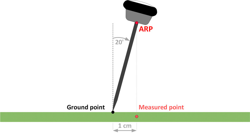
When measuring points with a GNSS RTK sensor in a conventional manner, the sensor must be held vertically such that the tip of the pole is vertically under the centre of the antenna (the Antenna Reference Point - ARP) - see Figure 1. By not holding the pole vertically, an error will be introduced to the measured point coordinates. The bigger the tilt, the bigger the error.
When measuring points in a conventional manner, a surveyor always tries to hold the pole as vertically as possible by watching the bubble attached to the pole. Most level bubbles attached to poles have a 20’ bubble. This means that even when carefully watching the bubble, it is easy for the pole to be tilted by 20’. A 2-metre pole tilted by 20’ introduces a 1-centimetre error to the computed ground coordinates.
In addition, since it is not easy to hold the pole vertical, still and simultaneously measure a point, many users will measure for more than 1 epoch (say 5 epochs). Over this time, any movement in the pole will be averaged.

Figure 1: Measurement error due to the inaccurately levelled pole
What tilt value is stored with the point?
If a point is measured with one epoch, then the tilt value that is stored with the point is the tilt value at that epoch. If a point is measured for more than one epoch, then the largest tilt value over the epochs when the point was measured is stored with the point.
Make sure to regularly calibrate the bubble on your pole
Of course, even if the surveyor watches the bubble and carefully holds the pole such that the bubble is centred, this is of no use if the bubble itself is not calibrated. It is a simple task, and we recommend pole bubbles are calibrated once a month, or sooner if the pole is dropped.
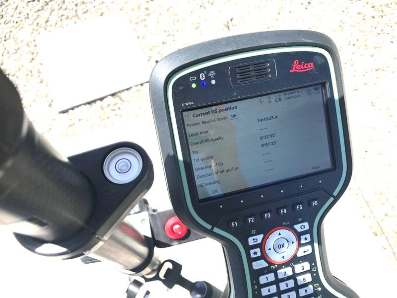
In addition, the GS18 T can of course be used to check the calibration of the bubble. Place the pole in a bipod, hold the pole vertically by watching the bubble and observe the tilt values in the Current GS Position panel.

Figure 2: Controlling the reliability of the level bubble with respect to the pole, inaccurate level bubble with respect to the pole
Ask for a demo, if you want to try the new “Store tilt only” functionality
This blog should give you a rough overview of the “Store tilt only” functionality within Leica Captivate and the GS18 T. If you would like more information, please contact your local Leica Geosystems representative – they’ll be more than happy to help.

Metka Majeric
Product Engineer at Leica Geosystems


