Behind the scenes of the fastest laser scanner on the market
Video feature

In today´s challenging environment, laser scanners can speed up workflows, empowering professionals from a wide range of industries to increase productivity and efficiency. The Leica RTC360 3D laser scanner is a compact field-to-office solution, filling the gap between the Leica BLK360 imaging laser scanner and the Leica ScanStation P-Series terrestrial laser scanners.
“At Leica Geosystems we have the ambition to build the best sensors in the world. When we designed the RTC360, we wanted to create something outstanding and unique,” said Juergen Mayer, president of Reality Capture Division at Leica Geosystems.
From surveying professionals, looking to scan quickly with high performance, to public safety authorities, aiming to use a portable and simple device with a practical post-processing software ─ the RTC360 is the solution.
Capturing up to 2 million points per second
The RTC360 3D laser scanner is developed to be fast, agile and precise. The fast and precise aspects refer to the unique capturing performance, such as 2 million points per second measurement rate and full High-Dynamic-Range (HDR) panoramic images in less than 2 minutes. Agile refers to its portability and automated targetless field pre-registration based on the special Visual Internal System (VIS) technology.
“The RTC360 was developed as part of a whole system, not a standalone scanner. It was developed together with field and office software with a truly unique technology called Visual Internal System (VIS) allowing to automate most of the workflows in registration,” said Mayer.
VIS technology was developed by Leica Geosystems experts to decrease the time spent on stitching together the individual point clouds into one complete point cloud. The system is based on five cameras built in to the RTC360 to track the environment. These cameras pick up on environmental features and use them as reference points to connect individual scans. When moving from one place to another, even between floors, the RTC360 knows the relative position between any two scans and automatically registers the different point clouds into one complete point cloud thanks to VIS.
“My first impression of the RTC360 is that the scanner is really amazing, because with the five additional cameras for the Visual Inertial System, the scanner has an additional sense to orientate itself,” said Markus Ziereis, regional sales manager at Leica Geosystems Germany.
Developing a compact solution

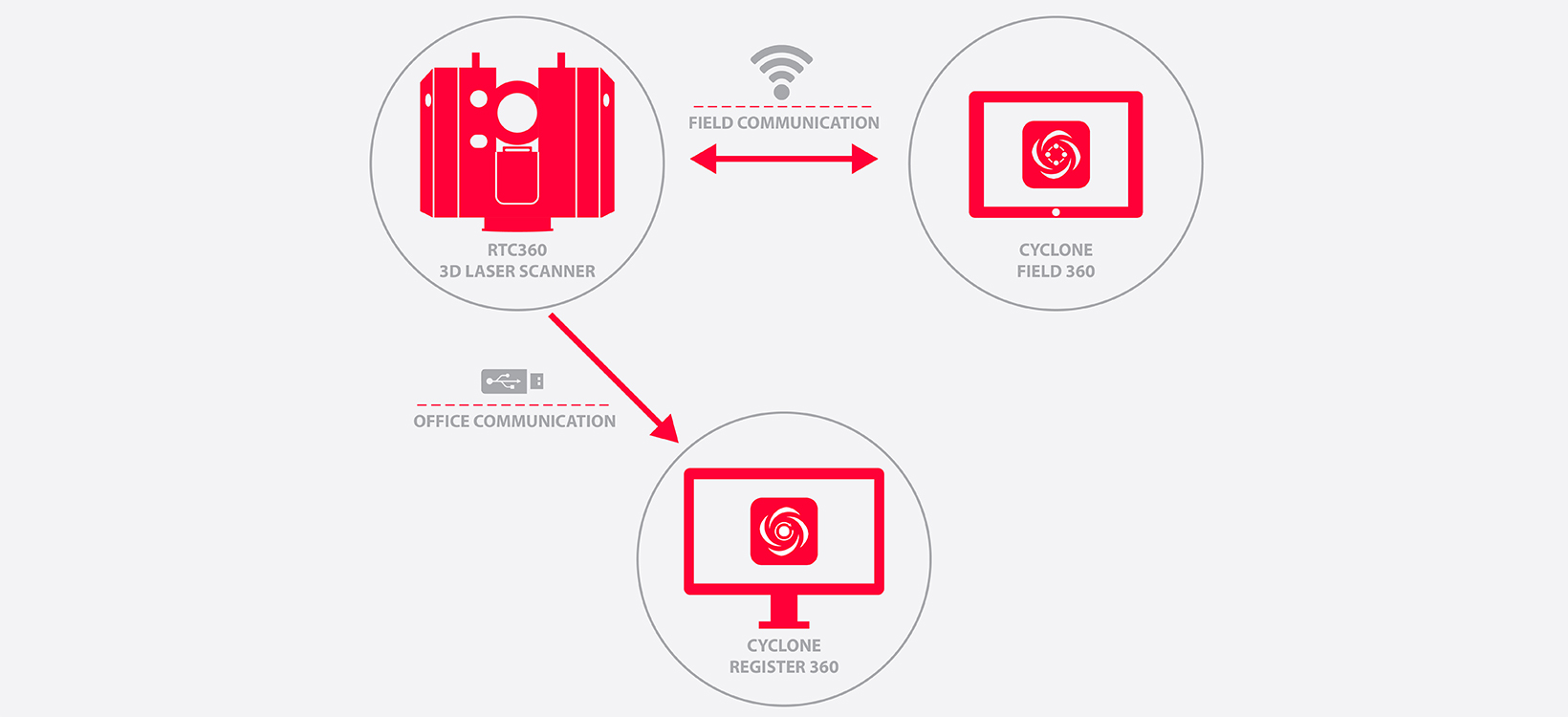
The RTC360 laser scanner is one component of an end-to-end system. The complete 3D reality capture solution consists of:
- Leica RTC360 3D laser scanner
- Leica Cyclone FIELD 360 mobile-device app
- Leica Cyclone REGISTER 360 3D laser scanning point cloud registration software
While scanning with the RTC360, users can operate their scanner and perform on-site point cloud pre-registration, straight from any iOS or Android device through the Cyclone FIELD 360 mobile-device app. With its intuitive user interface, and immediate data visualisation, the Cyclone FIELD 360 app allows users to quality control their scans directly in the field. Once all scans are checked and registered through Cyclone FIELD 360, it is synchronised back to the RTC360 3D laser scanner, which records the data on an USB stick and after plugging it into a computer, the post-processing can start with Cyclone REGISTER 360 post-processing office software.
Cyclone REGISTER 360 is an innovation for users of any skill level and makes the most of the RTC360’s innovations to dramatically reduce the user’s office workload. Cyclone REGISTER 360 provides a point cloud preview prior to import and leverages the Double Scan option of the RTC360 to automatically filter out all possible noise usually generated in busy locations. Within Cyclone REGISTER 360, users can fine-tune their pre-registration and prepare their data for use downstream in Leica Geosystems’ TruView and CloudWorx products.
This state-of-the-art 3D reality capture solution can be employed both by experts and novice users in a wide range of applications, including:
- Building construction
- Plant management
- Forensic science
“The RTC360 3D reality capture solution will be a massive benefit to customers, because it is going to speed up their workflow,” said Phil Marsh, HDS manager at SCCS Survey UK.
Tilmeld dig Leica Reporter
Kontakt Leica Geosystems
Ønsker du at vide mere? Vi er her til at hjælpe og vejlede dig.
Ønsker du at vide mere? Vi er her til at hjælpe og vejlede dig.
Leica RTC360 3D Reality Capture Solution – Behind the Scenes
A lot goes in to the preparation of such a big innovation project and training our global sales organisation is at the forefront every time.
A lot goes in to the preparation of such a big innovation project and training our global sales organisation is at the forefront every time.


